Agroecology Reading time 3 min
Democratising precision-guided agriculture: an ever-expanding Centipede-RTK network
Published on 03 February 2025

The Centipede-RTK (Real-Time Kinematic) project was created to provide farmers with inexpensive, reliable and easy-to-use solutions that make precision guidance technologies in agriculture more accessible to all.
These precision technologies make best use of resources, reducing environmental impacts and lightening the work burden for agricultural businesses. And precision is indeed required, since certain agricultural tasks call for levels of GPS accuracy down to the nearest centimetre, including seeding and hoeing, section control (to reduce application overlaps and gaps when spreading fertiliser), precision spraying, and the monitoring of water levels in gravity-fed irrigation systems.
First imagined in 2019 on a farm in Charente-Maritime, the project was then developed using INRAE’s CATI GEDEOP[1] platform.
The goal set by the project was to establish a dense network of satellite navigation base stations (GNSS, Global Navigation Satellite System) with the help of the RTKbase, and to use this to provide a correction data service in real time that would be open to all. This would enable high-precision positioning that could be accessed for free and independently of commercial products.
This open network was developed through a collaborative process, mobilising farmers, private businesses, scientists and communities, who together have installed the connections they need across the landscape to provide coverage tailored to their individual needs. Each base can be installed by the end-user with the help of on-line tutorials, and advice is available from the network community if users run into difficulties.
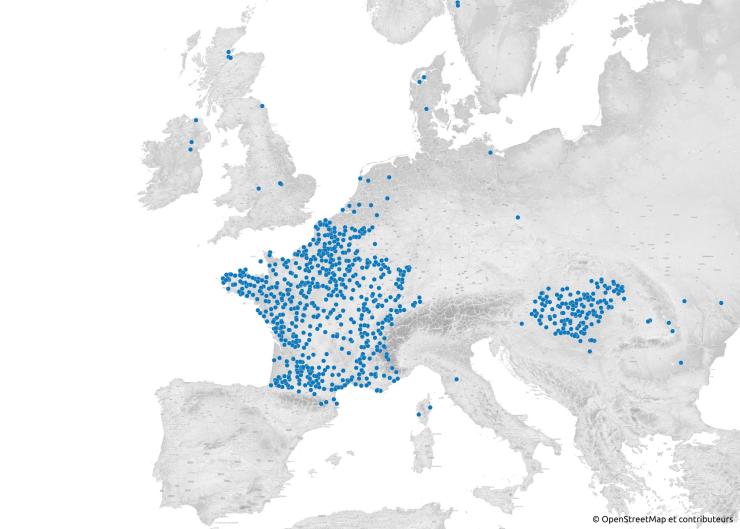
Since the project began, 625 bases have been installed in mainland France, with a further 860 bases now in operation across the world (in 30 different countries). There has been marked enthusiasm for Centipede-RTK in Hungary, where full national coverage has been achieved in under two years, with over 130 bases installed by local farmers. Other countries, too, are beginning to make use of the system, with regional clusters of GNSS bases emerging in Senegal, Serbia, England, Ireland, Norway, Denmark and Canada, for example. Beyond these groupings, individual farmers across the world, particularly in Equador, Israel and South Africa, are now using and contributing to the network.
Scientists, too, particularly those working at INRAE and the IUEM (European Institute for Marine Studies, Brittany), are using this technology in their work on meteorological monitoring, coastal monitoring, water and forest management, etc.
The formation of the non-profit Centipede-RTK association in August 2024 has made it possible to strengthen collaborations with various partners such as PCH (Packet Clearing House), the intergovernmental treaty organisation, with the specific purpose of expanding the network, originally centred on France, to become an international data infrastructure that remains open access.
[1] CATI GEDEOP: Automated centre for data processing, INRAE network ‘Management of data from experimentation, observations and practices in agro-socio-eco-systems’, 3rd generation, 2019-2025.
CentipOC: improving access to precision guidance in the Occitanie region of France
The local Chambers of Agriculture in Occitanie are planning to get farmers involved through the CentipOc project, supported by the Occitanie Regional Federation of Cooperative Users of Agricultural Machinery as part of the OccitANum Living Lab framework. Their goals are to expand the community of agricultural users, to raise awareness of the Centipede RTK collaborative and open source network, and to help farmers set up their own equipment and software to participate in Centipede.
CentipOC partners: FRCUMA Occitanie, Gard, Gers and Tarn-et-Garonne Chambers of Agriculture, OccitANum Living Lab run by INRAE.
Major French partners in Centipede-RTK
- RENAG (French National GNSS Network): provision of a robust GNSS to host the data generated and to strengthen the Centipede-RTK network.
- CNIG (French National Council of Geographical Data): strategic support for the communication of good practices in geomatics and the integration of Centipede-RTK products into land-based projects.
- INRAE: project created by engineers from the ACT and ECODIV (CATI GEDEOP) divisions and rolled out at institutional level with the support of the DipSO (Directorate for Open Science).
- LIENSs (French Coastal Laboratory for Environment and Societies, CNRS - University of La Rochelle): collaboration for the use and evaluation of the network in coastal environmental research.
- IUEM (European Institute for Marine Studies): key partner for marine and coastal applications.
- Local communities and regions: logistical support to strengthen local networks on the ground.
Reference
Ancelin J., Ladet S., Heintz W. (2025). CentipedeRTK, un réseau pour la géolocalisation haute précision au service de l’environnement. Journal of Interdisciplinary Methodologies and Issues in Sciences, DOI: https://doi.org/10.46298/jimis.14252