Agroecology Reading time 3 min
Satellite detection: from photo to video
Published on 16 December 2019

The orbital governance of crops and yields may sound like science fiction. Yet it is becoming more of a reality as remote sensing from space applied to agriculture shows progress. "Space imaging is keeping its promises. Today, many are using it to determine the nitrogen deficiencies of wheat", notes Thierry Caquet, INRAE Scientific Director for the Environment, whose long-term partnership with the National Centre for Space Studies (CNES) is getting stronger thanks to the framework-agreement signed on July 22nd 2019. The Sentinel 2 mission satellite pair, launched in June 2015 and March 2017 as part of the European Union Copernicus programme, offers a ten-metre soil monitoring resolution. Between 2020 and 2022, the constellation of four satellites of the Airbus Pléiades Neo mission should make it possible to achieve centimetric resolution, "at a rate of 30 centimetres over a 14 km2 area", adds Thierry Chapuis, expert in spatial applications at the CNES. "However", warns Thierry Caquet "all is not solved because we’re taking photos from space." The history of the process serves as a reminder that the challenges to be met remain significant.
New focus point
The cooperation between INRA - now INRAE following the merger of INRA and IRSTEA on 1st January 2020 - and the CNES is longstanding, since it started in 1986 under the impetus of the first SPOT missions for characterizing leaf surface areas. "Several problems arose at the time, and notably that of repeatability, in other words the need to revisit the areas concerned in order to monitor their evolution", Philippe Maisongrande, CNES research director, points out. "It was a “one shot” observation, and if there were no clouds nor scheduling conflicts, one overview report a month was produced, at best. It wasn’t enough." The SPOT-Vegetation 4 and 5 missions initiated in 1998 and 2001 filled the gaps thanks to kilometric resolution, a now daily crop monitoring approach, and the appearance of 3D imagery. However, monitoring isn’t the only issue at stake now. "We used to scrutinise the land and crops", Thierry Chapuis adds. "Now the whole question is to support and anticipate performances while taking into account crop adaptation to climate change, or by measuring pollution indices with a view to limiting the use of fertiliser or pesticides."
Yet once again, the technological race to increase spatial, temporal and spectral resolution is far from having solved the whole equation. On the one hand, Philippe Maisongrande observes, managing volume always requires the evaluation of the best possible resolution. "We have to find the right acuity." On the other hand, a technological effort needs to be made for obtaining more precise data concerning "what is still the 'poor relative' of remote sensing from space, that is to say the thermal factor". Led by INRAE alongside the CNES, the SMOS (for Soil Moisture and Ocean Salinity) mission has already made it possible to increase information on soil moisture and the measurement of its electromagnetic thickness. A high definition SMOS project with a 10-kilometre resolution by 2030 should help further refine data. In terms of water stress estimation, expectations are focused on the Franco-Indian mission Trishna, announced for 2024 and capable of offering a 50-metre resolution thanks to a re-evaluation every three days.
"Informational sandwich"
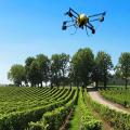
By gaining ground and near-microscopic precision in terms of its amplitude, satellite detection could a priori become a threat to lower-altitude remote sensing, and even to proxy-detection. Specialists are denying this possibility. "A drone is able to count plants, and a satellite isn’t, since it always depends on cloud cover. Advantages can vary according to the techniques used and they thus keep their complementarity", Philippe Maisongrande points out.
The most recent remote sensing operations from space have succeeded in promoting a new monitoring time frame. "We went from photo to video", says Philippe Maisongrande. Still it is necessary, insists his colleague Thierry Chapuis, for "information to best meet user needs by integrating into a data system". The multiplicity of data calls for their cross-tabulation within an information chain that is accessible and open to requests, an "information sandwich", to use Philippe Maisongrande’s term, defined at INRAE as a "strategic place" for reflection by Thierry Caquet.
Read the whole report: