Climate change and risks Reading time 7 min
One Water Vision: an international coalition supported by advances in satellite technology
Published on 24 January 2025

Pressures on water resources are reaching critical levels on a global scale. Now that prolonged droughts, failing aquatic ecosystems, ever-increasing rainfall variability and increasing competition for water between agriculture, industry and population centres are becoming commonplace, a coordinated response must be achieved. In this context, the One Water Summit, organised jointly by France and Kazakhstan, was held in Riyad on 3 December 2024, bringing together high-level political and economic players, funders and scientists.
One Water Summit: a key step towards a stronger global water agenda
- The One Water Summit is part of the series of One Planet Summits launched in 2017
- French President Emmanuel Macron stressed the strategic importance of scientific research in this process, placing access to reliable and regularly updated scientific data high on France’s list of priorities.
This vision can again be seen in the announcement of the One Water Vision initiative, an international programme of scientific cooperation involving more than 26 institutions from different countries.
One Water Vision: a research consortium emerging from the One Water Summit
- “The One Water Vision initiative has created an international research consortium (IRC), led by the World Meteorological Organisation (WMO) and the International Network for Basin Organisations (INBO), through an agreement signed at the One Water Summit”, explains Jean-François Soussana, who was INRAE’s Vice President of International Policy at the time of the launch, and who has since taken up his appointment as President of the High Council on Climate.
- The IRC, whose secretariat will be hosted by INRAE, is the result of a “mobilisation of French institutions (BRGM, CIRAD, CNES, CNRS, INRAE, IRD), working closely with the Ministry for Higher Education and Research, and brings together a score of international scientific institutions such as space agencies, national research bodies and universities”, he explains.
- One Water Vision’s goals are to develop innovative tools to monitor and manage water resources, to further develop early-warning systems for droughts and floods, and to provide reliable data to local decision-makers and users. “In a context of climate change and the increasing scarcity of water for agriculture in many areas of the world, One Water Vision will provide solutions that can contribute to global food security, and the conservation of water resources”, adds Jean-François Soussana.
What sets One Water Vision apart from other international water programmes is its emphasis on Earth observations and new satellite missions, such as SWOT and TRISHNA. The programme will make use of the services already provided and will take them to another level, providing users – river basin management bodies, countries and farmers – with practical and operational tools.
Satellite technologies to help the water cycle
The dual challenges of full coverage and high-quality data are the sine qua non of understanding and predicting the spatial and temporal dynamics of water as a resource. In this context, the SWOT (Surface Water and Ocean Topography) and TRISHNA (Thermal infraRed Imaging Satellite for High-resolution Natural resource Assessment) missions play a central role. These next-generation satellites, which are the products of international collaboration, bring hitherto unachievable resolution and accuracy to the analysis of water cycles, including coverage of isolated areas with little instrumentation.
Two satellites, two functions
- SWOT enables the analysis of surface water by taking precise measurements of levels and variations in water stocks in lakes and reservoirs, and calculating river flows.
- TRISHNA provides detailed information on the water taken up by plants and the soil, on the impacts of droughts on crops and ecosystems, and on the distribution of water resources at local and regional scales. It does so by observing evapotranspiration from vegetation on the ground.
SWOT: a revolution for continental hydrology
Until now, most altimetric satellites have been used for oceanography, lacking sufficient accuracy to map rivers or small lakes. Launched in 2022, SWOT is the first satellite designed primarily for inland water hydrology. “It’s a revolutionary project, both in its nature and its technical reach”, Pierre-Olivier Malaterre, a researcher at INRAE and a specialist in hydraulics tells us. Indeed, SWOT provides complete 2-D coverage of water levels at global scale with unrivalled accuracy.
“The data transmitted by SWOT are of remarkably high quality and have exceeded our most optimistic predictions. They will be providing us with research data for the next ten to twenty years”, states Pierre-Olivier Malaterre. From its orbit, 891 km above the earth’s surface, the satellite uses radar, penetrating cloud cover and outperforming visual monitoring techniques. It maps more than 6 million lakes and reservoirs on each pass and is able to measure water levels to within approximately 10 centimetres.
These data open up new opportunities to:
- guide and support human water use: irrigation, drinking water, industrial reservoirs, hydroelectric production, navigation
- protect wetlands and fragile ecosystems
- analyse changes in the hydrological cycle brought about by droughts and floods.
While a key aspect of its mission may be to collect data beyond the Earth’s oceans, the SWOT satellite also represents a major step forward for oceanographics, measuring sea levels “to the nearest centimetre”, says Pierre-Olivier Malaterre. These data are already being used for a variety of purposes, notably in calculating sea currents and predicting wave heights. They are also integrated into advanced meteorological forecasting models, thus contributing to improvements in the understanding and prediction of ocean dynamics.
Collaboration at top international level
The outcome of a Franco-American partnership between the CNES and NASA, the development of SWOT has depended on intensive collaboration between scientific colleagues. INRAE’s expertise in hydrology and hydraulics has earned it a place in this process:
- Recognised expertise. INRAE has been working with the CNES on this project for a decade, drawing on its researchers’ specialist knowledge of hydrology and hydraulics. One of INRAE’s researchers now occupies a key role in the SWOT scientific project: Hind Oubanas, based in Montpellier, has taken on the management of the hydraulics side of the project, having spent two years on secondment as a visiting scientist at NASA.
- Calculating river flows: SWOT measures the surface elevation, width and slope of river water, but does not directly provide data on the corresponding discharge of the rivers it monitors. With his US counterparts, Pierre-Olivier Malaterre oversees one of the mission’s required products, combining the observational data provided by the satellite with other data to compute river flows. The discharge estimates are produced by using six algorithms, validated by the SWOT Science Team. Two of these algorithms were developed and tested by the French team.
A practical example: the Congo basin
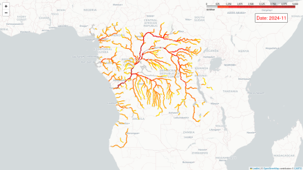
The Congo basin, the second largest river basin in the world, offers an excellent opportunity to showcase SWOT’s potential for improving transboundary water resource management. With just two or three ground-based gauging stations in operation for this basin that extends across nine countries, data on water levels and flows are very sparse. SWOT fills this gap by providing regularly updated mapping of river and lake water levels that can be freely accessed by all the countries concerned. These data make it possible to improve the forecasting of flood and drought risk and to help build collaborative water management between riparian States.
A further major benefit of these satellite projects lies in the free open data they make available. This open access helps to build international cooperation and allows the integration of data with the primary purpose of providing critical support for resource management and risk forecasting.
TRISHNA: Observing ecosystem temperature and water dynamics
Jointly developed by the CNES (France) and the ISRO (India), TRISHNA will be launched in 2026. Equipped with a high-precision infrared thermal sensor developed by the French teams, TRISHNA records surface temperatures with a spatial resolution of 60 metres and a revisit frequency of 2 to 3 days.
The temperatures it measures serve as key indicators for the mapping of vegetation evapotranspiration rates across the entire surface of the globe. A major function of the water cycle, evapotranspiration returns water directly to the atmosphere without entering groundwater or river systems.
- Higher evapotranspiration levels reduce the earth’s surface temperature, since water consumes heat as it evaporates
- Plants under water stress reduce their transpiration levels, increasing surface temperatures.
“The data we make available on evapotranspiration will provide real added value for water management – up to now, it simply hasn’t existed”, stresses INRAE researcher Albert Olioso, a specialist in remote sensing and water resources and the creator of the mathematical models needed to calculate the relationship between the temperatures measured by TRISHNA and evapotranspiration.
The previous generation of satellites are indeed unable to provide precise and regular monitoring of evapotranspiration. TRISHNA, with its frequent passes and high resolution, will fill this gap. “For agronomists, access to these data on evapotranspiration will make it possible to improve predictions and optimise irrigation management”, explains Albert Olioso, stressing the benefits this scientific achievement will bring to the strategic planning of farm water management.
Several satellite projects have already tried and failed to incorporate these parameters. In 2008, the CNES began its current push to find a solution, drawing on the combined expertise of INRAE and the IRD. Over the years, Jean-Pierre Lagouarde (INRAE) has shaped the mission in his role as Principal Investigator for a working group established by the CNES, making a decisive contribution to its progress. More recently, Albert Olioso has joined an international advisory group on the development of the LSTM (Land Surface Temperature Monitoring) satellite mission by the European Space Agency (ESA), ensuring its coordination with TRISHNA and other future satellite missions such as the US-Italy SBG mission.
Support for multiple services
Other than measuring evapotranspiration, TRISHNA will provide essential data to tackle other environmental challenges:
- monitoring of inland and coastal waters: analysis of temperatures and water variations in lakes, rivers and coastal zones
- monitoring of land-based ecosystems: detection of water stress in forests and natural zones
- study of urban areas: observation of heat islands to understand the impacts of urban development
- observation of the cryosphere: monitoring of ice sheets and glaciers to assess changes in snow and ice cover.
Strategic support for water and risk management
The data provided by TRISHNA will thus enable:
- optimisation of agricultural irrigation: precision adjustments to water provision based on crop needs
- prediction of environmental risks: monitoring of early signs of droughts or wildfires, often linked to reduced evapotranspiration
- modelling of climate impacts: integration of temperature and water data to refine weather and climate forecasting
- study of water dynamics: improving resource management for lakes, rivers and coastal zones.
The SWOT and TRISHNA missions are game changers in the observation and management of global water dynamics. With the One Water Vision initiative, the analysis of these data will make it possible to transform these satellites’ observations into practical actions that meet strategic challenges:
- strengthen transboundary cooperation by providing free access to trusted data and information to all stakeholders, to allow an equitable management of shared resources in international basins
- develop early warning systems that can accurately identify the signs of drought, flooding or water stress, in near real time, using tools that draw on remote sensing and artificial intelligence
- adapt local practices to global needs, mobilising farmers and land managers in the co-creation of appropriate adaptive solutions, such as irrigation optimisation and crop management in regions hit by drought.