Biodiversity Reading time 12 min
AI and remote sensing: a potent combination supporting research to save tropical forests
Published on 02 March 2023

The One Forest Summit is part of the series of One Planet Summits organised by France since 2017, addressing planet-wide issues. On March 1st and 2nd, 2023, in Libreville, Gabon, it attracted world-class scientists, funding bodies and businesses to address the preservation and sustainable management of tropical rainforests in the Congo, Amazonian and South Asian tropical basins. These forest zones are critical for climate regulation, supporting a rich diversity of flora and fauna, and their conservation also plays an essential role in the prevention of future pandemics.
INRAE participated through the PREZODE initiative session, to strengthen the initiative with new African countries joining. Philippe Mauguin, CEO of INRAE, and Jean-François Soussana, INRAE Vice-President of International Policy signed an open letter published by scientists in the French newspaper Le Monde on March 1st, to alert on the need to protect and manage forests to reduce future pandemics risks.
Led by INRAE, CIRAD, and IRD, the initiative now has 200 members, both governmental and institutional participants who are working to prevent the emergence or re-emergence of epidemics of animal origin.
This summit was created to provide a platform for concrete scientific and economic initiatives to implement the political ambitions that emerged from the Paris and Glasgow climate agreements and from COP15 on biodiversity, with Positive Conservation Partnerships (PCPs) discussed by the High Ambition Coalition (HAC) for Nature and People. An intergovernmental group, the HAC seeks to champion conservation policies and brings together more than 100 countries, under the co-presidency of Costa Rica, France and the United Kingdom.
Building Positive Conservation Partnerships for a conservation at the heart of tropical forests
‘We can see that the actions resulting from climate negotiations and the Redd+ mechanisms to reduce deforestation have not been sufficient to halt the deforestation and degradation of tropical forests’, explains Jean-François Soussana, International Vice President at INRAE.
According to the UN’s Food and Agriculture Organization, 420 million hectares of forest were lost to deforestation between 1990 and 2020. Nor should we forget the forest degradation caused by actions that are often illegal such as logging, deliberate fire-setting, or gold mining. Current estimates reveal that the extent of forest degradation and its impact on carbon emissions are of roughly the same order as those of deforestation. This means that, despite the utmost importance of monitoring deforestation, this measure is not enough on its own. We also need to establish a warning system for degradation and to develop adapted and adaptable strategies for forest conservation.
To achieve this, a scientific session, co-chaired by Gabon and France, was organised at the summit as part of the launch of a new initiative, One Forest Vision (OFV), and coordinated by INRAE and CIRAD. A number of French research institutes (CEA, CIRAD, CNRS, INRAE, IRD) worked at the request of the French Ministry for Higher Education and Research to prepare the project.
"We now need to conserve the heart of these forests for their biodiversity and carbon storage. That was the commitment at COP15 – to protect 30% of the world's land surface, and to conserve key ecosystems by 2050" Jean-François Soussana
An initiative that combines the most advanced forest monitoring methods
The Congo basin will be the first area to pilot advanced monitoring methods, with studies on forest degradation, biodiversity and carbon storage at scales ranging from landscapes to regions, combining measuring stations, inventories, remote sensing and artificial intelligence (AI) with citizen science and sustainable management practices. The extension of the project to other tropical rainforests is also under consideration.
Integrating information at landscape scale. The first step is to study biodiversity (flora and fauna, soils), forest structure and dynamics, and carbon sequestration using data from instrumented super-sites supplemented by information drawn from forest inventories. These data, acquired at landscape scale, are essential for the proper calibration and validation of calculations performed at national and regional scales based on remote sensing data.
Monitoring each tree in the forests of the Congo basin. Recent advances in remote sensing combined with AI make it possible to detect the individual trees in a forest. Frequent acquisition of high-resolution satellite images (from Sentinel 1 and 2 and Planet in particular) make it possible to assess the extent of forest cover, carbon storage and degradation, to map the different types of ecosystem and to calculate biodiversity indicators.
Co-constructing monitoring systems for tropical forests. The forest monitoring system which this enables begins with local communities on the ground, and extends to national, regional and international levels, allowing the environmental integrity of protected forests to be safeguarded. Significant actions are required to expand capacity and training by research and to develop local skills in citizen science that can give indigenous populations, local communities and forest nations the capacity to master their own data and take decisions based on a shared and transparent information system that is readily accessible via a digital platform.
A further phase of action is being explored. This would unlock financial support for space agencies and would involve the completion of the record of CO2 exchanges at the scale of the Congo basin, in order to understand whether it still functions as a carbon sink, or whether deforestation and degradation have together turned it into a net CO2 emitter. This phase would require repeated aerial surveys to measure the CO2 in the atmosphere and study its composition, following the example of the Brazilian Amazon. Flux towers also need to be installed in the Congo basin to supplement its sole existing tower, located in the Yangambi biosphere reserve, operating along the same lines as the Guyaflux tower in French Guiana run by the ECOFOG Joint Research Unit (Ecology of French Guianan Forests).
In short, in the view of Jean-François Soussana, who acted as rapporteur for the summit workshop, ‘If we succeed with One Forest Vision, local communities, indigenous populations, forest nations and the international community will gain access to all the tools they need to record and check the conservation status of tropical forests. They will also be able to develop a network of protected areas in order to conserve key ecosystems and identify practices that will not compromise environmental integrity’.
Remote sensing in the age of artificial intelligence: a major research tool
‘We have long used remote sensing to track the dynamics of forests at global scale, in terms of surface area, height, or again biomass. But our knowledge of these different parameters remains incomplete, their evolution through time is hard to track, and our data are patchy and sometimes very varied, depending on the methods used’, explains Jean-Pierre Wigneron, research director at INRAE's Bordeaux Centre.
How the science works.
‘VOD vegetation indicators’: global reference products
INRAE has developed the Vegetation Optical Depth (VOD) vegetation index, with many VOD products based on data from microwave satellite systems such as SMOS, SMAP and ASCAT. They are recognised world-wide as reference products for aerial monitoring of forest biomass. The development of these VOD products by the ISPA Joint Research Unit (Soil-Plant-Atmosphere Interactions) has enabled a scientific breakthrough – the tracking of variations in carbon stocks in global forests across many decades at resolutions of 10-20 km. Although the spatial resolution of this index is not sufficient to produce a detailed mapping of forests, VOD made it possible for the first time to add a temporal dimension, going back more than 20-30 years, to the high-resolution mapping (~ 100 m) of forest biomass via complementary methods.
Applications around the world
- Satellite observations in Australia led to the discovery that biomass losses from forest fires were compensated by the strong resilience of the Australian forest.
- In Siberia, forest fires were observed to act as a counter-balance to the increase in stored carbon encouraged by rising temperatures.
- In the Tropics, the degradation of the Amazonian forests was shown to have as great an impact as deforestation on biomass losses.
- In Africa, VOD made it possible to assess the important function of semi-arid regions in the dynamics of carbon storage, following the droughts of 2014-2016.
- In China, the index has made it possible to quantify the effects of reafforestation on carbon storage.
With greatly improved resolution (30 m), optical remote-sensing products using the Landsat satellite have been providing data on deforestation since the 1980s. They do not, however, provide precise information on biomass and forest degradation. Major recent advances based on very-high resolution remote-sensing images and AI have now made it possible for forest monitoring to work at the scale of the individual tree and differentiate trees affected by deforestation or degradation.
The scientific breakthrough made possible by artificial intelligence
With the very rapid development of AI, in particular that of Deep Learning, new approaches have made it possible to monitor forests at the scale of the individual tree. A forest’s biomass can thus now be estimated based on the characteristics of each and every tree within it. It is AI that has made this possible, using optical observations to estimate tree shape and density, and drone, plane or satellite LiDAR to estimate their height.
A new study, led by NASA and the University of Copenhagen and published in Nature, to which INRAE contributed, has thus combined AI with satellite images to produce detailed information on the distribution of trees across all African drylands north of the equator. In concrete terms, these new methods open the door to assessing the dynamics of forest degradation, the status of biodiversity and changing levels of carbon storage. They have made it possible to map Rwanda at individual tree scale and the mapping of Europe and Africa is now underway.
Jean-Pierre Wigneron is delighted: 'It’s a revolution – before we had to use remote sensing to monitor forests using vegetation indexes that were often hard to interpret. Now we are able to map all the trees in the drylands of Africa and estimate the biomass, height, and crown area of each tree, at a very fine scale’. At national scale, it will be possible to monitor carbon stocks and recognise trees, landscapes, species and forest habitats to improve understanding of their relationships.
Truly a breakthrough in scientific terms, this new tree-scale approach can only currently provide a static image of a tree’s current status, without the perspective that would be necessary to understand changes through time. To obtain a temporal overview, the results must be combined with data from other approaches.
This is where the use of VOD can help, adding a temporal dimension to the assessment of carbon stocks across the region studied. Currently, this approach is limited by the need to access data from very high resolution satellites owned by the private sector. The OFV initiative is intended to overcome this obstacle by creating an open access data platform.
The CEA’s Laboratory for Sciences of Climate and Environment (LSCE) currently works with INRAE using an AI Deep Learning approach at 10 m scale. It combines the data from Sentinel 1 and 2, available free of charge from the European Space Agency, with NASA’s open-access GEDI data, providing the means for AI to be trained to estimate height. The results are validated through reference to INRAE’s Bordeaux inventories along with those held by the French national geographic institute (IGN). Mapping of the Landes forest at 10 m has been completed and validated[1] and a map of France is underway.
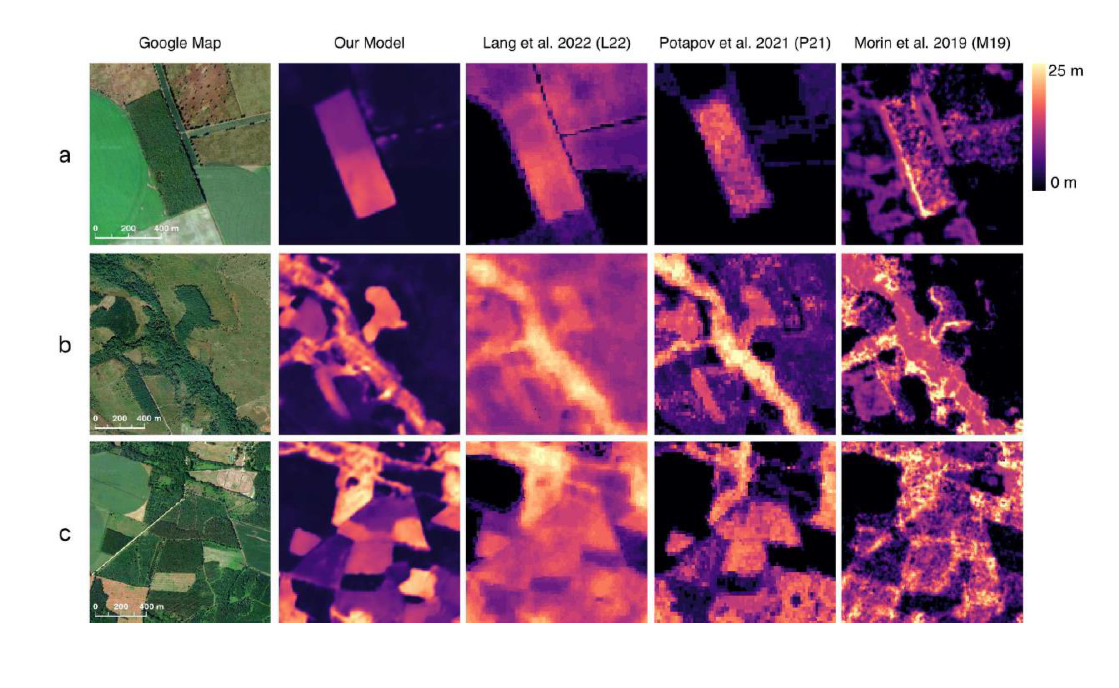
Credit: Schwartz M. et al. (2022)
Future directions for research
INRAE’s contributions to the One Forest Vision will include the landscape-scale data it provides on the carbon cycle and data from the Kisangani flux tower, along with the provision of expertise on forest inventories and the relationships between habitats and biodiversity. In French Guiana, considerable expertise has been developed on the understanding of forest ecosystems by members of the ECOFOG Unit and the Centre for the Study of Amazonian Diversity LabEx (excellence laboratory) working with the CNRS, and this could be put to use in the measurement campaigns planned by the project.
The Soil-Plant-Atmosphere Interactions Unit in Bordeaux and the LSCE will together develop the remote sensing approach to the Congo basin. This builds on their collaborative mapping of the Landes area in a jointly supervised thesis, work that is now being extended to the rest of France. The team will also call on the support of Kayrros, a leading start-up in the use of AI and remote sensing in the field of energy and the environment. INRAE will contribute to the training and mobility of researchers, in particular those from central Africa, the pilot zone for the initiative, with the help of the TSARA research partnership, comprising 17 African members, CIRAD and INRAE.
The One Forest Vision complements other French research programmes on forest issues and will contribute to the international priority programme initiated by INRAE on forests and climate change.
Launched in 2022, TSARA aims to strengthen research partnership cooperations to promote sustainable agriculture, food systems and agricultural, pastoral and forest landscapes. INRAE has already allocated new resources to promote scientist mobility.