Ressources dossier
Climate change and risksA whole-system approach to a fast-changing risk
Published on 06 February 2023

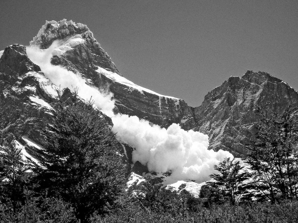
Should all development be banned in high-risk zones, or should these areas instead be provided with protective infrastructure? The twin demands of development and safety mean that planning decisions are always hard-fought in mountain areas. Decisions concerning avalanche risk can cost millions of euros, but their cost can also be counted in human lives. The evaluation of this risk demands complex research at widely differing scales and in different domains, from the study of the physical processes involved in avalanches to monitoring the ever-changing patterns of hazards, vulnerability and exposure that combine to produce it.
A research unit to investigate all aspects of avalanche risk

1970 was a difficult year for French mountain communities. On February 10, an avalanche engulfed a UCPA holiday-centre chalet in Val-d’Isère, leaving 39 dead. Then, two months later, on the Assy plateau, a landslide formed of a mixture of mud, snow and water buried a sanatorium, causing 72 further deaths.
These two tragedies acted as a wake-up call. The French authorities realised that the country had few defences against natural events such as these, events that were both recurrent and hard to predict. They asked the CTGREF1 to set up a snow study service, the ETNA Research Unit on Torrential Erosion, Snow and Avalanches at INRAE. ETNA became the Institute of Environmental Geosciences (IGE) joint research unit IGE in January 2023. The newly fledged ETNA service’s principal mission was to build a better understanding of avalanche risk. “In its early days, the unit was chiefly interested in mapping avalanche locations and in developing and improving protective structures”, Florence Naaim, IGE’s deputy director, tells us as she looks back over the unit’s development. “We then began to study the snow itself, looking more closely at the physics of avalanches. Nowadays we also take account of the potential impacts, the vulnerability of those at risk, and we factor in all the physical and social mechanisms that contribute to the risk. So, we don’t just concentrate on the hazard, we look at the risk in the round, adopting a whole-system approach.”
This methodology recognises the systemic nature of risk and the fact that each of its three dimensions – hazards, vulnerability and exposure – evolves differently. It is an approach that the Sendai framework (2015)2, in particular, has worked hard to promote. Indeed, to be able to predict the harms caused by an event, we must understand how several different factors (such as climate, topography, the spatial practices of societies and their development choices) can combine to produce a disaster, calling for a vision that is both comprehensive and interdisciplinary. The current profile of the research team reflects this need – the researchers, engineers and technicians who make up its thirty members hail from different disciplines, so that specialists in physics, modelling and measurement work alongside statisticians and historians…
Observe, model, quantify
The tradition of recorded observations in this field goes back to the creation in 1899 of the French Permanent Avalanche Survey (EPA), still jointly managed with the French National Forest Office and the Ministry for the Ecological Transition. At first, the survey’s approach was largely founded on the natural sciences, but it expanded in the 1970s to include research in physics and process modelling. In the early years of the millennium, in order to improve risk quantification, designate zones where risk could be considered acceptable, and optimise mitigation strategies, the Institute’s researchers coupled deterministic models of avalanche spread with the statistical data provided by the EPA. This resulted in increasingly accurate probabilistic numerical models designed to evaluate “exceptional avalanches” (with a 100-year return period). Working first at the scale of a single avalanche path, the modelling was then scaled up to take in entire ranges, making it possible to evaluate the hazards for paths that were either poorly documented or unrecorded. This probabilistic hazard analysis, carried out first at local and then at regional scale, has enabled us to characterise the variability of avalanche activity at different spatio-temporal scales. It helps us to understand why certain ranges are more active than others, taking account of their topography and locations, and to use meteorological “forcing” to explore the links between avalanche activity and weather.

Meanwhile, methods were also developed to model vulnerability to the impacts of an avalanche, examining how vulnerabilities in both the built environment and those who live in avalanche zones could contribute to the risk. These models were then coupled to the quantitative hazard models, enabling individual risk models to be calculated that could be expressed in mortality figures or destruction levels, and protective structures to be optimised. Further parameters drawn from the human and social sciences are now adding to the sophistication of the models.
This fresh input means that expert historians can, for example, help to make better use of archive materials to feed current models. Likewise, historical analysis of development decisions taken by businesses and of their perceptions of risk can be incorporated into our understanding of current vulnerabilities and exposure factors, enabling us to act appropriately.
We might be forgiven for assuming, therefore, that avalanche risk is under control. Sadly, this is far from the case. At present, the socio-environmental systems in our mountains are undergoing a process of very rapid flux brought about by global change (to the climate, society, etc.), meaning that the risks, too, are changing.
The many impacts of a changing climate
New patterns of avalanche risk threaten high mountain communities, despite the overall decrease in snow cover.
To deal with this, we first needed to understand how climate change is affecting the hazards themselves. The research teams began by studying changes in avalanche activity at climate-process scale. This enabled them to show that a series of very harsh winters produced a peak in avalanche activity in France at the beginning of 1980 and that, from the mid 1980s onwards, avalanches at low and mid altitudes then became less frequent and smaller, with a greater proportion of wet snow avalanches. Looking to the future, work conducted jointly with the French meteorological service’s Centre for Snow Studies using the IPCC projections (see p. 9) made it possible to demonstrate that current trends are set to intensify. Thus, for example, a 20 to 30% overall reduction in avalanche activity is projected during the 21st century as the consequence of drastic losses in snow cover. We should nevertheless note that avalanches at high altitudes do not follow this trend. Indeed, at these altitudes, extreme snowfall may cause the number of avalanches to increase for a time before it falls again, with a continued chance of major dry and cold snow avalanches occurring, such as the 1999 Montroc avalanche in the Chamonix valley. In that event, 14 chalets were swept away and 12 people were killed. The team is currently working to improve the accuracy and detail of future projections of avalanche patterns, incorporating their number, intensity, location and seasonality into the calculations.
The impacts of tourism and buildings
The pace of change for other determinants of avalanche risk is no slower, indeed, it may even be faster. As the climate heats up and agro-pastoral activities are abandoned, we are seeing a rapid reafforestation of the slopes. Meanwhile, the footprint of development continues to expand overall, spurred on, in particular, by the growth in winter tourism. Brand new avalanche protection structures are going up alongside existing structures that may be showing signs of wear, sometimes for lack of maintenance, producing a shifting picture of overall exposure levels. Research is ongoing to reveal the workings of this complex process (which can vary greatly from one local context to another), pulling together qualitative and quantitative analysis at different spatio-temporal scales. It has been possible to show, for example, that in very high alpine valleys, the risk to buildings and their occupants would appear to have risen in the past few decades, as their exposure increases to a continued hazard. By contrast, at lower altitudes, risk levels are falling due to a combination of reduced snow cover and the gradual regeneration of trees along avalanche flow paths, sometimes all the way up to the avalanche starting zones. Quantitative analysis has helped us to demonstrate that it may be possible to adapt to these changes by strengthening exposed buildings and managing our forests for protective purposes, gaining greater control of risk levels.
This, then, is the new pattern of avalanche risk that threatens high mountain communities, despite the overall decrease in snow cover. Stakeholders in such areas are being asked to develop an adaptive approach in their long-term investment strategies, but to do this they must have access to detailed and reliable information. The whole-system approach and increasingly detailed studies produced by the research community will help these decision-makers to develop a detailed understanding of the changing nature of the threat they face.
NOTES
- ↑ CTGREF: This technical centre for the French National School of Rural Engineering, Water Resources and Forestry was an early predecessor of IRSTEA, which merged with INRA on 1 January 2020 to form INRAE.
- ↑ The Sendai framework for Disaster Risk Reduction 2015-2030, adopted by the third United Nations World Conference, was the most recent in a series of documents ratified since 1994 to improve risk reduction at global level.
A dataset unlike any other
It is a commonplace that one avalanche will be followed by another. In 1899, when out surveying avalanche damage, Paul Mougin, an engineer working for the French Water and Forests service, decided it was time to try something new – the creation of an inventory of every avalanche that had occurred in Savoie. He intended his records to preserve details of the events along with details on the extent of the forest damaged each year.
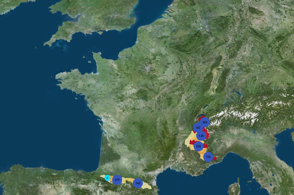
850,000 hectares mapped, 25,000 avalanche impact sites catalogued; 13,000 interviews and witness accounts collated.
Paul Mougin could not know that, 120 years on, his work would still be continuing. Every winter, year after year, 260 ONF staff still collect the avalanche data for 3600 flow paths in 11 départements across the French Alps and Pyrenees. They scrupulously record dates, starting-point and run-out altitudes and volumes, along with a wealth of other details. These data are recorded in the EPA, the French permanent avalanche survey which, to date, has amassed more than 100,000 observations.
Following the Val-d’Isère disaster in 1970, the French government asked for a map to be produced to accompany this catalogue of events. The map would show the maximum extent of the damage caused by the events in the catalogue and is known as the CLPA (French Avalanche Event Location Map).
The CLPA provides a record of historic and observed events by mapping the extreme limits of the areas physically impacted by them. It is produced by members of the IGE joint research unit, who first record photographic interpretations and field observations before collating archive documents, interviews and witness statements from local mountain inhabitants and professionals. The EPA and the CLPA, both of which are funded by the DGPR (Directorate General for Risk Prevention) of the French Ministry of Ecological Transition, and are managed by INRAE, allow each event to be tracked through time and space, their complementary visions offering a unique dataset for use by expert advisers and researchers. They are available through open access on www.avalanches.fr.
SEE THE INTERACTIVE MAP OF THE LOCATION OF AVALANCHE PHENOMENA
-
Sebastiàn Escalon & IGE joint research Unit
Authors / Translated by Teresa Bridgeman
-
Thierry Caquet, Mohamed Naaïm & Patrick Flammarion
Scientific direction
-
Lou Rihn
Illustrator