Ressources dossier
Climate change and risksWater distribution in the French regions
Published on 02 September 2022

National and local dialogue
Goal: to achieve a 10% reduction in water extractions across all sectors between now and 2025
In May 2021, the French government launched its "Varenne agricole", a national debate on water and adaptation to climate change in farming 1. It followed on from the country’s 2019 Water Assizes, and these two debates have resulted in a list of actions that include the agreement of shared rules for water management and distribution. The goal is to achieve a 10% reduction in water extractions across all sectors (domestic, industrial and agricultural) between now and 2025, rising to 25% by 2035.
Key players in this landscape of debate are the newly created PTGEs. These regional water-management projects focus on the management of supply and demand, and are being set up under a central government initiative 2. PTGEs establish, commission and assess action plans to balance water needs and resources within an area while preserving the local environment. They are founded on a prospective vision that takes account of climate change. It is expected that they will be inclusive of all stakeholders and will open up a dialogue, particularly between farmers and other parties, including environmental protection groups. More than 60 PTGEs have been authorised so far, and a further 40 or so are in the pipeline. Typically, a PTGE is catchment-based (100 – 1000 km2) and is often characterised by a particular water-related issue (lack of water, flooding, water quality) that has to be managed alongside various economic activities (production, processing, tourism). PTGEs build on existing formal water-governance structures, including CLEs, the local water commissions that act as sorts of "parliaments for water", bringing together all stakeholders to create their own water supply and management plan (SAGE) 3. A rainfall catchment, or river basin, is defined as the land area drained by a given watercourse and its tributaries. The water from the basin converges towards a common exit point known as the outlet (see illustration).
1. Varenne de l’eau: a joint collaborative project initiated by the French ministers for agriculture and the environment, with participation from chambers of agriculture, local authorities, state services and operators, scientists, water users, environmental protection groups, etc.
Its purpose is to create an operational roadmap to respond to the challenges of water management in agriculture. All regions have already embarked on an assessment phase using a shared methodology.
2. The role of PTGEs was laid out in the central government directives of 4 June 2015 and 7 May 2019 issued to regional authorities (basin coordination prefects, regional prefects et al.,) to encourage their introduction where desirable. Authorities designated to oversee the process include Chairs of CLEs (local water commissions), EPTBs (regional river basin public authorities) or EPAGEs (water supply and management authorities), or any other locally recognised authority in water management.
3. A SAGE is a catchment-based plan that puts in place the integrated management of water resources and of aquatic habitats, setting goals for water quality and the good functioning of habitats. Such plans contain a regulatory process to enable the impartial designation of priority uses and allocation of quotas according to use.
The water-sharing areas in France

France (excluding its overseas departments and territories) is divided into 7 major regions that are loosely based on the major French river basins (Adour-Garonne, Artois-Picardie, Loire-Bretagne, Rhine-Meuse, Rhône-Mediterranean, Seine-Normandie, Corsica). These main basins are subdivided into a network of sub-basins, or catchments.
To create and assess plausible water-management scenarios, we have to understand the catchment hydrology involved. ‘The seven major French river basins have been modelled, some with a greater degree of confidence than others’, Vazken Andreassian, an INRAE hydrologist explains. ‘Indeed, some of these catchments are complex, containing groundwater storage areas which capacity is hard to estimate’.
Participatory engineering, the keystone of local projects
Access to water and its allocation can be causes of serious conflicts. In France, the tragic events that occurred in 2014 in Sivens (Tarn), where a young ecologist died during a protest against the construction of a dam, acted as a wake-up call. They led to laws and regulations in France requiring the involvement of all stakeholders in projects from the outset 4.
Such ‘upstream’ co-construction takes time, and high-quality tools and training are required to support it. In France, it is currently the exception, as the prevailing world view of elected representatives and officers has been shaped by a system where public consultation occurs only after the evaluation and planning stages have been completed by experts and decision-makers.
INRAE’s scientists are leaders in the field of participatory engineering, having developed both the necessary tools and a holistic approach to participation. In the words of Nils Ferrand, a self-described "experimenter in transformation", "if transformation is imposed, it generates resistance in a community. Expert models are not enough, they have to tap into local knowledge". This process can be made easier by a toolkit known as COOPLAGE, the fruit of 20 years of development, that enables the co-construction of strategies that combine scientific and lay knowledge, allowing participants greater self-governance. The toolkit is currently used in more than forty countries to tackle a range of social and environmental issues, with training programmes for stakeholders and a MOOC (Terr’Eau & Co.). In Tunisia, for example, government officers have been trained since 2018 to develop a more participatory approach to local water management in six rural areas. A similar process has been conducted in Ceará in Brazil.
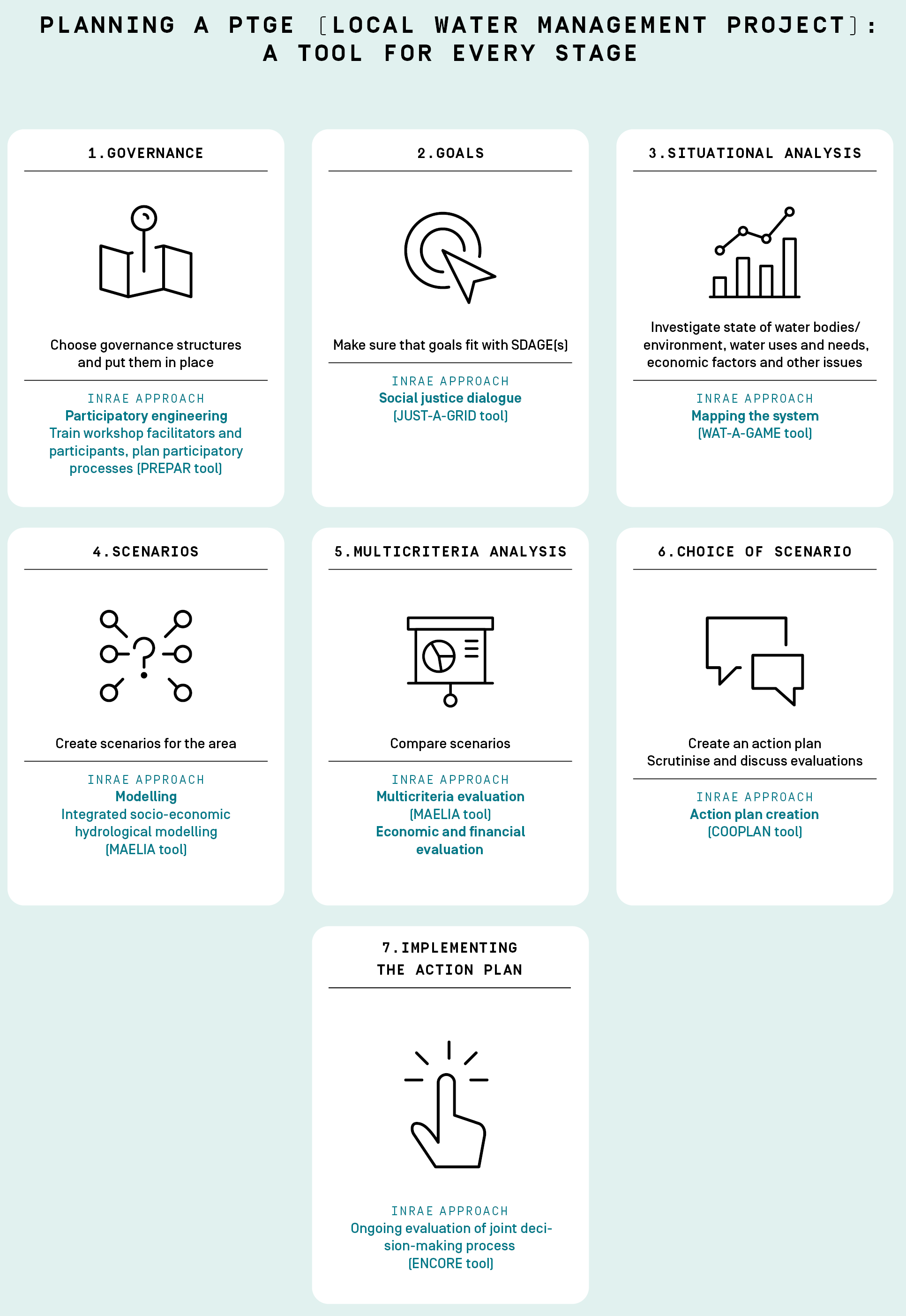
A wide assortment of different tools is available for every phase of the participatory process from the preparatory phase onwards (see below). To validate the decision-making process, the PREPAR (pre-participation) tool helps upstream agreement to be reached on the roles to be played by different actors and facilitates an engagement process to establish how the proposals of stakeholders will be taken into account. A major innovation, this first requires decision-makers to be willing to discuss the participatory process itself. The second condition for success is that the stakeholders should be able to produce a shared assessment of the situation, using different methods such as role play and the use of fact sheets, diagrams and grids (WAT-A-GAME tools), to share their visions of social justice (JUST-A-GRID), and to work together to build a coherent local action plan (COOPLAN tool). Last, the ENCORE tool replaces post hoc feedback with ongoing evaluation of the whole participatory process, enabling adjustments to be made to the process where needed. This formidable array of tools encourages stakeholders to question themselves at every stage of the process, to broaden their attitudes to change and to become more adept at its management. ‘A shared journey, dialogue, and the restoration of trust are the building blocks for the co-construction of a sustainable local project’, concludes Nils Ferrand.
4. French Government Decree 2016-1060 of 3 August 2016 on the Environmental Debate.
Planning a PTGE
Participatory engineering in action
NEW CALEDONIA
First shared-water policy
Using the COOPLAN toolkit and guided by professional consultants, it took just 9 months for New Caledonia to produce its Shared Water Policy (PEP) through a participatory process. Adopted unanimously by the island’s Congress in 2019, it involved one in every 600 inhabitants. This is no small achievement, given that water governance is particularly complex in this French overseas community where different realms of authority overlap, including national government, provinces, towns, and the traditional chiefdoms, part of whose role is to protect sacred springs. The process allowed participants to come up with innovative proposals, not least that water should be given the status of a legal living person. Mining industry representatives revised their position, approving the protection of strategic water resources in some nickel-rich mountain ranges, thereby effectively renouncing their right to mine there. At the end of the process, 90% of participants said they had gained a better understanding of the problems associated with water.
A COOPERATIVE CONSULTANCY
Lisode, the participatory engineering experts
The work of INRAE’s scientists inspired the creation of the Lisode cooperative society in 2008, providing participatory engineering services and advice for public water-supply projects. So far, Lisode has supported around a hundred co-constructed projects and has provided training for some thousand professionals. ‘We continue to work with researchers to improve our understanding of what is needed to make co-creation a success’.
LES USSES
The community where local views on water management are changing
The views of the inhabitants of Les Usses, near Annecy, on water management have undergone an overhaul. Tensions over water run high in this very rural area which is nevertheless densely populated because of its proximity to the Geneva economic basin. Initially convinced that the main consumers of water in their area were farmers, local people came to realise that their own water usage was far higher and came up with an action plan to reduce it. Training for the project coordinators was delivered by scientists from INRAE. A forerunner of the PTGEs, the project conducted its collaborative work over a two-year period (2017-2018), building this into social activities – walks, discussion cafes, theatre and role play – often forming part of larger events (country fairs and nature festivals), in order to connect with as many people as possible. In the words of one elected representative "the project’s approach changed how inhabitants viewed the syndicate [Usses Rivers Syndicate, ed], in its role as the overall management body for water, looking beyond the more visible operations it carries out on watercourses such as tree-works, etc." One of the project leaders, inspired by what she saw at a theatre workshop, has this to say: "you can’t just say to farmers, ‘stop watering your maize so much’, instead you need to say, ‘let’s see if there is a different way of managing the crop, a different variety, a different crop’. You don’t say, ‘don’t do x’, instead you say, ‘together we need to do things differently." The feedback from the inhabitants of Usses and from 4 other representative projects in the Rhône-Mediterranean-Corsica basin, has been made available to the water agencies through a dossier distributed by INRAE.
Taking the heat out of the debate: can modelling help?
Three questions to Delphine Leenhardt, an agronomist at INRAE.
Scientists at INRAE have helped to calm troubled waters in a sub-catchment of the Aveyron by setting up a process that combines stakeholder participation with impact scenarios and modelling. The purpose of the process was to explore solutions to the recurrent water-supply difficulties experienced in this region and to overcome strong differences between stakeholders. Delphine Leenhardt supervised two action-research theses on this topic between 2011 and 2018.
What problems does this area face?
Delphine Leenhardt: In this catchment, water extractions repeatedly exceed the authorised thresholds designed to maintain the DOE 1 and this has led to water rationing. It has caused conflict between farmers who irrigate their crops, many of them maize producers, on the one hand, and local people who seek to protect the environment on the other. Many of the fields along the Aveyron river are irrigated and the water abstractions for this purpose are compensated by the release of water from reservoirs further upstream. In the hills surrounding the Aveyron’s tributaries, there are also close on 400 small reservoirs, some of which are poorly maintained, and these can have negative impacts on the environment.
These circumstances have provided the basis for 4 scenarios selected by the stakeholders for comparison. The scenarios were produced using the MAELIA model, which makes use of 28 indicators that cover impacts on both water and agricultural production. The model pulls together information on hydrology and on the decisions made by farmers (on seed types and irrigation) and water managers (on controlled water releases and rationing). It creates a picture based on the everyday decisions that are made by upwards of 1,000 farmers about the management of more than 15,000 plots of land.
What have you learned by studying these scenarios?
Delphine Leenhardt: The first scenario replaces the small reservoirs with 3 reservoirs of the type known as "substitution reservoirs", which fill up in winter and are used in summer. For the same irrigated area, this scenario results in a rise in water abstractions (+24%), accounted for by the fact that the limited capacity of the small reservoirs has acted as a brake on irrigation. This scenario was the most criticised by participants, including farmers, because it shows no commensurate increase in productivity and appears to waste water. It also calls for significant investment in infrastructure. This scenario nonetheless has some benefits for aquatic habitat conservation, with an increased likelihood of remaining on the right side of the DOE threshold. Of the 4, the most efficient in reducing water abstractions (-42%) is the scenario that includes conversion to agroecological principles, where crop diversification means all irrigated maize monocultures are replaced by an irrigated maize – sunflower – wheat – rape rotation. This scenario also requires the most substantial changes in practice and carries a reduction in gross margins of 9%. The two intermediate scenarios feature the use of decision-making tools to manage irrigation and a halt to irrigation in the upper catchment.
What have you learned about the participatory approach?
Delphine Leenhardt: One of the strengths of this study has been that we created and assessed the scenarios in collaboration with the stakeholders. We divided them into interest groups – water managers, environmental groups, farmers, etc. – to avoid exacerbating existing disagreements. As it transpired, a mutual curiosity was displayed between the groups and they wanted to share their views. During the plenary discussions, we saw consensus emerge, for example on the advantages of using decision-making tools for irrigation management, but also on sticking points such as the creation of reservoirs which, participants felt, was slowing the progress of the transition to agroecology by encouraging irrigation and intensive agriculture. We observed that stakeholders’ judgements of the scenarios were actually based not just on water savings but also on the sort of agricultural system associated with each scenario (ie agroecology or intensive farming). Last, shared proposals did emerge, for example, to condition the creation of reservoirs through contractual requirements to engage in agroecological practices. This project shows the importance of high-precision modelling for the impacts of the scenarios. Use of objective indicators can make possible a genuine and more measured debate between stakeholders with different agendas.
1. DOE: minimum outflow value. The DOE is the minimum flow level required by the SDAGE above which all uses can coexist normally while maintaining the proper functioning of the aquatic habitat.
Working out the cost-benefit ratio
For local projects to succeed, they need ways to assess economic and financial implications, and to help with this, INRAE is making tools available that have already been tried and tested on the ground.
"Building infrastructure, restoring canals, advising and training stakeholders, developing and communicating information – all these actions have price tags that should be weighed against the benefits for the area. Despite this, few PTGEs currently carry out detailed economic assessments", comments Sébastien Loubier, an economist at INRAE. Being cognizant of this gap, the French Ministry of Agriculture called on INRAE for help and the Institute’s teams responded by producing a Methodological Guide to the Economic and Financial Analysis of agricultural PTGEs 1. The guide provides a protocol that can be used by project leaders to assess the economic implications of local scenarios, looking as far as 40 to 50 years into the future. Decision-makers can explore the economic future of their local areas, both with and without the project. This is important because failure to act in areas where there is tension over water can blight a locality, resulting in lower river levels, fewer abstractions, less agriculture and fewer public services.
Experiments at landscape scale
The Guide’s methodology has been tested out on the ground by several PTGEs. The Hauts de Provence Rhodanienne PTGE (2017-2020) is a living demonstration of the close ties between agriculture and water management. In this area to the North and East of Avignon, the PTGE is seeking to protect overexploited groundwater by achieving a 30% reduction in abstractions, not an easy task when the region’s chief sources of income – high-quality wines, aromatic products and perfumes – depend on crops with high added value, all of which require greater irrigation as the result of climate change. The project, which is led by the Vaucluse Chamber of Agriculture, plans to pipe water from the Rhone to catchments suffering from water shortages. Economic analysis showed the project to be viable, despite the infrastructure costs involved and the projected increase in the area of irrigated land, because of the benefits it would bring to the premium crops grown in this area where vineyards are the chief source of income. They also bring secondary benefits such as wine tourism in this inland area where tourism alone cannot fulfil the development needs of the region.
Economic assessments
"Economic assessments are important because they tell us whether a given scenario is economically desirable and viable for each group of stakeholders. But they can’t tell us whether a scenario is the best option for the management of water resources or for the environment – for that we need to apply other criteria. There is a question mark over the Vaucluse project’s viability in the longer term – although the Rhone would currently appear to be a dependable source of water for now, we don’t know how long this will continue to be the case. When we are looking at the future of grape production, we have to consider alternatives to irrigation, for example the use of a variety of levers to help the crop to adapt to drought (choice of fruit or graft varieties, farming practices, etc.). In return for access to water for irrigation, some vineyard owners could trial these possible solutions on parts of their estates", suggests Sébastien Loubier, who advised the project on methodology.
Importance of data collection
"Economic analysis calls for the collection of much data from farmers, public authorities and services, chambers of agriculture, water agencies, etc. This compilation of high-quality information is essential if economic analysis is to provide a sound objective basis for decisions that take us beyond entrenched ideas and conflicts. It also creates an initial space for cooperation. It calls for the investment of both the time and resources necessary to address the issues", concludes Patrice Garin, an agricultural geographer at INRAE and one of the authors of INRAE’s economic and financial guide.
1. Analyse économique et financière des Projets de Territoire pour la Gestion de l’Eau (PTGE) à composante agricole : principes méthodologiques et exemples d’applications, S. Loubier, P. Garin, E. Hassenforder, M. Aucante, C. Lejars, 2021.
-
Pascale Mollier / translated by Teresa Bridgeman
Author
- Vazken Andréassian Hycar research unit
- Nils Ferrand, Delphine Leenhardt, Sébastien Loubier, Patrice Garin G-EAU joint research unit