Ressources dossier
AgroecologyExamples of digital tools for agriculture and the environment
Published on 07 April 2023
Livestock farming: prevention is better
than cure
A new method using IA to enable the detection of 90 to 100% of anomalies on cows caused by health problems.
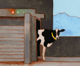
Since the early years of the millennium, the monitoring of individual animals has meant that farmers can now tell at an early stage if their animals have health or behavioural problems or have come into season. Nathalie Mitton, a researcher at Inria and co-author of the white paper Agriculture and Digital Technology offers us one example: “One of our doctoral students founded a start-up that manufactures collars to monitor the health of cows. Usual behaviours (oestrus, calving) and unusual behaviours (limping, problem behaviours) as defined by farmers are incorporated as parameters in the tool. The data is transmitted by the sensors and analysed by artificial intelligence (AI). If there is a problem, an alarm is triggered, so that farmers don’t have to keep going back to their animals to check their health. It’s a step forward, both for animal welfare and for the farmers, who no longer have to perform so many painstaking and mentally-demanding tasks.”
Similarly, machine learning and an indoor tracking system for individual dairy cows were used by INRAE doctoral student Nicolas Wagner to develop a health detection method in his thesis1. His method enables the detection of 90 to 100% of anomalies caused by health problems, often as much as 2 days before the first clinical symptoms can be detected by the farmer.
1. Thesis title: Detecting changes to the pattern of animal activities across the day linked to pre-pathological states, stress, or a reproductive event, 2020.
Pollination and biodiversity: follow the bees

It is essential for beekeepers to track their bees to ensure good production levels and the availability of forage materials, but more frequent visits to the hive generate higher costs and each visit acts as a stressor for the insects. Based on research carried out by INRAE (Beelive project), the BeeGuard company has, since 2016, been selling systems to monitor hives and pollinator behaviours.
By installing sensors on the hives and elsewhere, beekeepers can monitor the good functioning of the hive without disturbing it, checking indicators for temperature, humidity and return rates to the hive. Information on the bees’ comings and goings allows the beekeeper to keep an eye on resource levels in the surrounding area and to be alerted to any unanticipated rise in the mortality rate. Thus equipped, hives can act as early-warning systems for the quality of the environment.
Crops: detecting mildew with drones
The early detection of diseases and the exact location of infected plants help to optimise crop treatment and, above all, to reduce the use of phytopharmaceutical products. At farm scale, disease recognition and water stress programmes have been developed, such as that developed by Bordeaux company Chouette to detect the first signs of mildew on vine leaves using facial recognition principles. The drone carrying the camera is connected to GPS, providing vineyard owners with a map showing the exact location of the infected plants. Wine growers can then act early, targeting just the infected zone. Not only will this system allow them to reduce the spread of disease by taking early action, by facilitating the highly-targeted application of treatments, it will also reduce their use of phytopharmaceutical products.
Land management: satellites to help environmental planning

The DINAMIS (National institutional hub for the shared provision of satellite imaging) platform brings together public and private partners from research and industry, including the French national centres and institutes for space studies (CNES), scientific research (CNRS), development research (IRD) and agricultural research for international development (Cirad), along with the French version of the Ordnance Survey (IGN), Airbus and, of course, INRAE to provide access to a range of commercial images produced from optical data with very high spatial resolution, and a link to free high-resolution visual data and radar, using images from the Pléiades constellation and SPOT 6-7.
Images from Sentinel 2 will soon also be available. With an image resolution of up to 500 mm, the data allows the monitoring of agricultural fields (buildings, type of use, stage of crop growth, diseased zones), forested areas (species, felling, damage from disease) and bodies of surface water. These data are highly useful for development policies or local spatial planning, and for environmental monitoring and management.
Traceability: databases for labelling

Farming and food production now generate large quantities of production data (origins, expiry dates, ingredients, time spent on pasture) that only digital technology is capable of processing, analysing and reproducing. Data is transmitted at all points along the production line to the end user, facilitating each production stage and, ultimately, feeding the databases of scoring systems such as Nutriscore or Eco-score, high-end quality-control systems such as the AOC/AOP and IGP systems, or labels such as the AB organic label in France. In France, two platforms host the national databases. HubAlim2 tracks data on agricultural products, while Num’Alim3 collects information on industrially-processed food products, adding in corporate social responsibility data for each producer.
Apps such as YUKA4 use Num’Alim’s reference database (Univers’alim) as their source, the latter covering more than 250,000 food products sold in France. The data is displayed on packaging or can be accessed via on-line food sales sites.
2. B2B agrifood platform which provides data on products from the farming sector.
3. Platform that collects data on processed food products for consumer apps.
4. Yuka is a mobile app that scans the information in a product’s bar code to identify products that are bad for the consumer’s health. It alerts users to high levels of of additives, salt, fat, or sugar in food products, and to potentially dangerous contents (endocrine disruptors, carcinogens, allergens) in cosmetics.
-
Aliette Maillard
(Send email)
Author / Translated by Teresa Bridgeman
-
Sophie Nicaud
Author
-
Philippe Fontaine
Author
-
Nicole Ladet
Author