Climate change and risks Reading time 3 min
Anticipating drought severity via river-flow data
Published on 09 August 2022

What are the benefits of the tool your researchers have developed?
Vazken Andreassian: Serious droughts can cause major reductions in river flows. In some regions, even access to drinking water can be affected, meaning that supplies must be brought in by road. It is therefore essential to be able to predict these events so that they can be managed as well as possible. The French public services keep a very close eye on river flows using data from multiple measuring stations sited along our watercourses. The collected data are sent to a national database (HYDRO).
The tool we have developed (PREMHYCE 1) enables us to use these data, along with predictive modelling, to forecast river flows in the short (0-15) and medium terms (16-90 days), making it possible to anticipate what restrictions on water usage may need to be imposed as a function of the predicted streamflows. Decisions on this are taken by the prefects of the départements, who then issue restriction orders (see the 2022 map).
How does the tool work?
V. A. In practical terms, the tool operates as a website that combines several predictive models2. The shorter-term forecasts (up to 15 days) are based on rainfall predictions. Beyond 15 days, a climatic approach is used – streamflow predictions are based on many years of observed relationships between climate and river flows. The data we select to feed the models (chosen from around a thousand measuring stations) are representative of the status of each watercourse and provide full coverage of an area. For example, we won’t pick a measuring station that is just downstream from a dam since the flows it records will reflect the water-release schedules of the dam’s managers rather than local rainfall. We send the predictions from the various models, along with our uncertainty assessments, to each regional public body (DREAL 3), which then analyses these short and medium-term results so it can provide the best information possible to decision-makers at the prefectures.
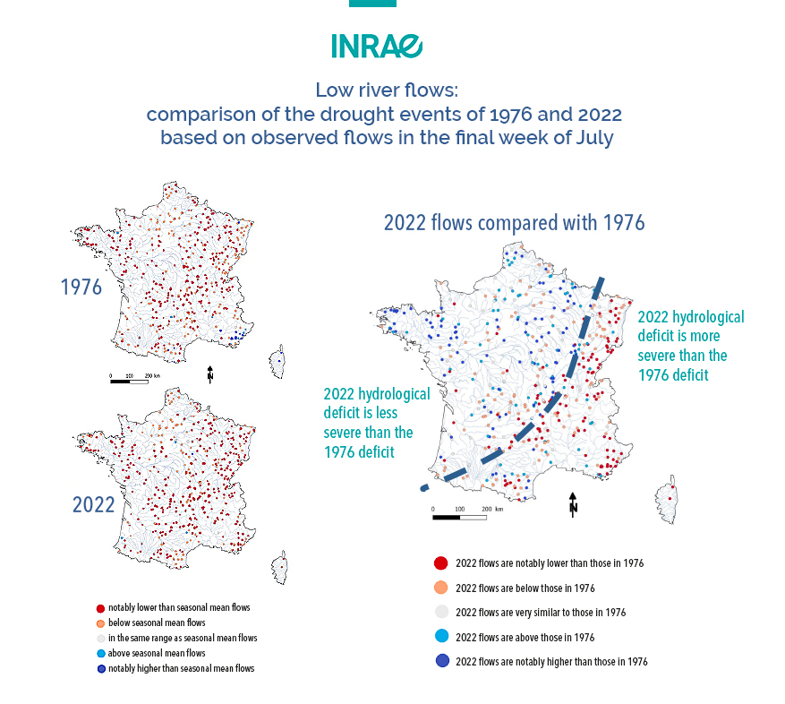
Why compare the data on river flows from 1976 and 2022?
V. A.: The media regularly ask this question. The comparison is well founded, in that 1976 is the historic drought year that has most in common with the current year, in terms of both the duration and extent of the drought, which is affecting the whole of France.
Looking right now, at the beginning of August, at the data on river flows in 1976 and 2022, we can confirm that the two droughts are both comparable and serious. This year’s drought has been more marked in the east of France compared with 1976 but has been a little less severe in the west. France has repeatedly experienced severe episodes of drought (the previous two were in 1921 and 1949). We need to be vigilant, because the IPCC predicts a likely increase in the frequency of such major droughts and, above all, we need to anticipate their impact and do something about it!
- The PREMHYCE tool, see inset.
- These are the meteorological, climate and hydrological models produced by INRAE, the BRGM (French geological survey), EDF (national electricity supplier), the University of Lorraine and the French forecasting service Météo-France
- DREAL: regional directorate for environment, development and housing.
The PREMHYCE programme and its partners
PREMHYCE (low-flow forecasting with hydrological models, comparison and assessment) is a research programme coordinated by INRAE, with support from the OFB (French biodiversity agency) and the French Ministry for Ecological Transition. It brings together teams from the BRGM (French geological survey), EDF (national electricity provider), Météo-France (weather forecasting service) and the University of Lorraine. PREMHYCE produces flow forecasting for several hundred reporting points in France, for up to 90 days ahead.
The work of PREMHYCE has been extended through a research project funded by the ANR, the French national research funding body, known as CIPRHES (integrated chain for the hydrometeorological forecasting of low flows and droughts). INRAE is coordinating this project, working with its existing PREMHYCE partners. The project aims to further develop novel approaches to integrated hydrometeorological modelling for low-flow forecasting, based on the PREMHYCE model for ensemble streamflow prediction. Contact: charles.perrin@inrae.fr.